


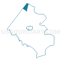
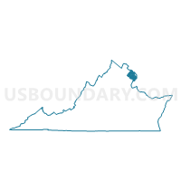
Seneca Voting District, Fairfax County, Virginia
About
Outline

Summary
| Unique Area Identifier | 681468 |
| Name | Seneca Voting District |
| County | Fairfax County |
| State | Virginia |
| Area (square miles) | 6.79 |
| Land Area (square miles) | 6.77 |
| Water Area (square miles) | 0.02 |
| % of Land Area | 99.71 |
| % of Water Area | 0.29 |
| Latitude of the Internal Point | 39.02618310 |
| Longtitude of the Internal Point | -77.33981360 |
Maps

Graphs
Select a template below for downloading or customizing gragh for Seneca Voting District, Fairfax County, Virginia


Neighbors
Neighoring Voting District (by Name) Neighboring Voting District on the Map
- Aldrin Voting District, Fairfax County, VA
- Clearview Voting District, Fairfax County, VA
- Forestville Voting District, Fairfax County, VA
- Lowes Island Voting District, Loudoun County, VA
- Montgomery Precinct 06-009, Montgomery County, MD
- North Point Voting District, Fairfax County, VA
- Seneca Voting District, Loudoun County, VA
- Sugarland Voting District, Fairfax County, VA
Top 10 Neighboring County Subdivision (by Population) Neighboring County Subdivision on the Map
- Hunter Mill district, Fairfax County, VA (128,052)
- Dranesville district, Fairfax County, VA (114,174)
- District 6, Montgomery County, MD (52,514)
- Sugarland Run district, Loudoun County, VA (26,287)
Top 10 Neighboring Place (by Population) Neighboring Place on the Map
- Reston CDP, VA (58,404)
- Great Falls CDP, VA (15,427)
- Dranesville CDP, VA (11,921)
- Sugarland Run CDP, VA (11,799)
- Lowes Island CDP, VA (10,756)
- Darnestown CDP, MD (6,802)
Top 10 Neighboring Unified School District (by Population) Neighboring Unified School District on the Map
- Fairfax County Public Schools, VA (1,081,726)
- Montgomery County Public Schools, MD (971,777)
- Loudoun County Public Schools, VA (312,311)
Top 10 Neighboring State Legislative District Lower Chamber (by Population) Neighboring State Legislative District Lower Chamber on the Map
- State Legislative District 15, MD (137,447)
- State House District 32, VA (112,677)
- State House District 34, VA (74,627)
- State House District 36, VA (74,325)
Top 10 Neighboring State Legislative District Upper Chamber (by Population) Neighboring State Legislative District Upper Chamber on the Map
- State Senate District 33, VA (316,436)
- State Senate District 32, VA (191,978)
- State Senate District 15, MD (137,447)
Top 10 Neighboring 111th Congressional District (by Population) Neighboring 111th Congressional District on the Map
- Congressional District 10, VA (869,437)
- Congressional District 8, MD (728,124)
- Congressional District 8, VA (701,010)
Top 10 Neighboring Census Tract (by Population) Neighboring Census Tract on the Map
- Census Tract 7006.04, Montgomery County, MD (6,802)
- Census Tract 6112.09, Loudoun County, VA (6,503)
- Census Tract 4804.02, Fairfax County, VA (5,936)
- Census Tract 4805.02, Fairfax County, VA (5,784)
- Census Tract 6112.05, Loudoun County, VA (5,774)
- Census Tract 4820.01, Fairfax County, VA (4,801)
- Census Tract 4804.01, Fairfax County, VA (4,526)
- Census Tract 4801, Fairfax County, VA (4,239)
- Census Tract 4805.01, Fairfax County, VA (3,604)
Top 10 Neighboring 5-Digit ZIP Code Tabulation Area (by Population) Neighboring 5-Digit ZIP Code Tabulation Area on the Map
- 20874, MD (57,367)
- 20170, VA (41,236)
- 20164, VA (37,747)
- 20165, VA (32,383)
- 22066, VA (18,099)
- 20194, VA (13,165)